Intended Audience and Contact Information
| Contact | Chief Data Officer, Office of the CIO |
|---|---|
| UDM Domain | Location |
| Intended Audience | Internal UBC |
Purpose
This standard aims to achieve consistency in the definition of the concept of a First Level Parcel at UBC, the boundaries of a parcel, and the format in which data associated to these is collected and stored across the University.
Parcels at UBC follow a two-level hierarchy. This standard defines the first level parcels.
Standard
First Level Parcels are large blocks of land bounded by roads or major pedestrian corridors. Areas occupied by roads and major pedestrian corridors are also defined as first level parcels themselves.
The following are the general principles used for defining parcel boundaries:
- The UBC Land Use Plan and Okanagan Campus Plan serve as a guideline for boundary definitions.
- First-level parcels are drawn considering dedicated rights-of-ways not owned or not managed by UBC.
- First-level parcels are generally constant over time. They will remain unchanged unless development occurs and requires realignment.
- When development does occur, parcels will be modified or archived.
- Where possible, parcels employ simple geometry (avoiding uneven boundary lines from specific physical features)
- For tranportation parcels, roads are grouped representing the total area for each sub-type
- Road parcels are drawn to include sidewalks.
- In limited cases (key character features), main pedestrian corridors may include adjacent landscaping (e.g. Main Mall includes the Oak trees in the corridor)
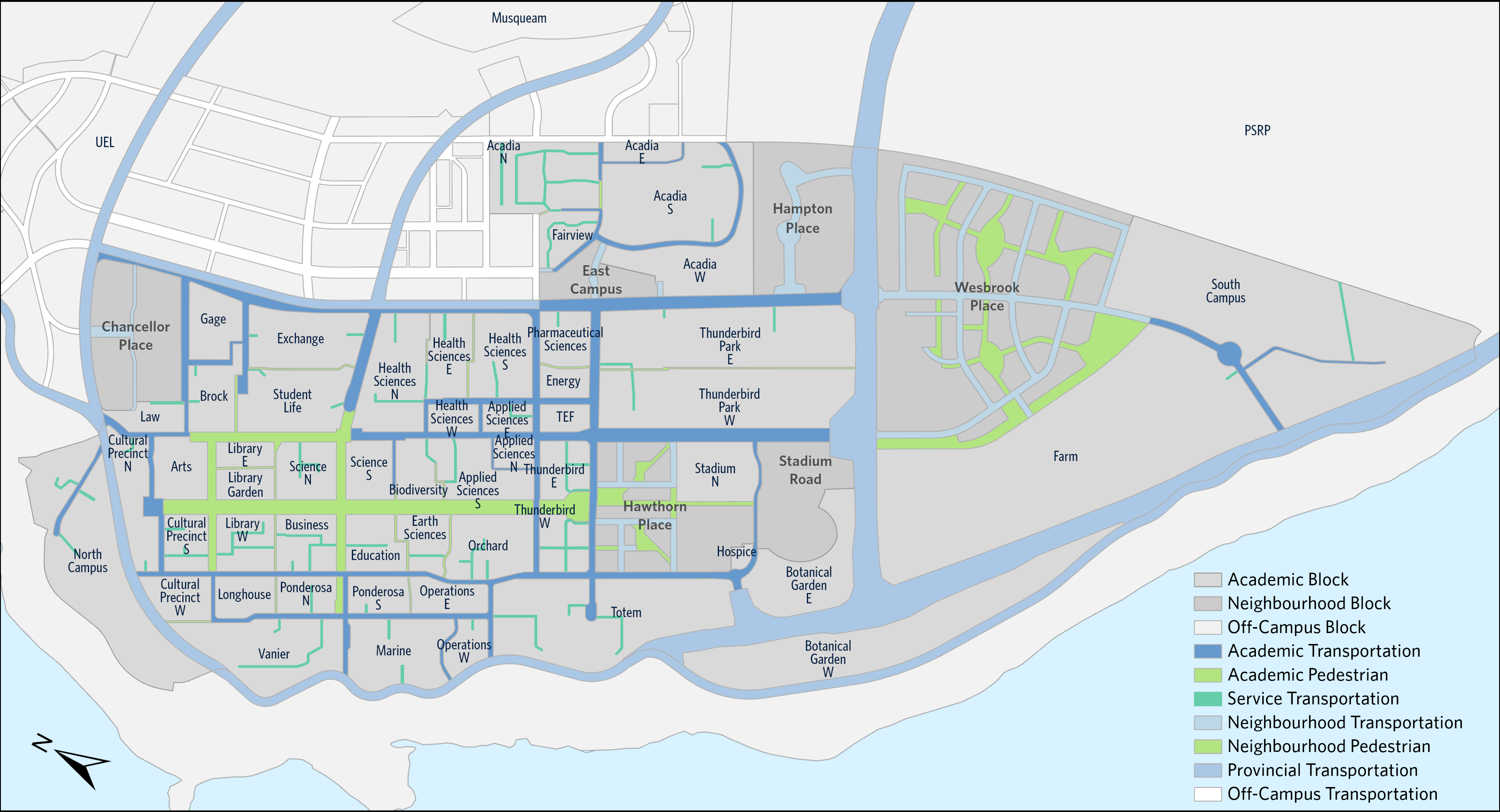
View the map of the First Level Parcels-Vancouver Campus. Okanagan Firslt Level Parcels will be developed at a later date. For a definition of Property or Parcel refer to the UBC Property Data Standard. For Second Level Parcels, refer to the Second Level Parcel Standard.
| Attribute | Definition |
|---|---|
| Identifier | Unique Parcel identifier of the form: LP10001, LP10002. |
| Parcel Name | Name assigned to the parcel. See below for Parcel Naming Guidelines. |
| Ownership | The individual or entity who owns the land parcel. Possible values |
| Jurisdiction | The extent or range of judicial, law-enforcement, or other authority. |
| Parcel Type | The type of parcel based on its intended use. See below for accepted values. |
| Parcel Sub-Type | A sub-categorization of parcels based on intended use. See below for accepted values. |
| Area | Parcel area in m2, as calculated in the GIS system |
| Building area | Total GBA from Buildings within each parcel |
| Accepted Data Value | Definition |
|---|---|
| Block | Portions of land bounded by transportation corridors |
| Transportation | Portions of land for transportation purposes (for example: walking, cycling, driving or transit or rapid transit) |
| Accepted Data Value | Definition |
|---|---|
| Academic Block | Portions of land that are for Academic purposes. |
| Neighbourhood Block | Portions of land that are within Neighbourhood Housing Areas (Vancouver campus only). |
| Off-campus Block | Portions of land that are not within UBC's campus. |
| Provincial Transportation | Dedicated road rights-of-ways that are under the jurisdiction of the BC Ministry of Transportation and Infrastructure. |
| Academic Transportation | Roads (includes the sidewalk) intended for or used by the general public that are within UBC's Academic lands. |
| Neighbourhood Transportation | Dedicated road rights-of-ways located within Neighbourhood Housing Areas (Vancouver campus only). |
| Off-Campus Transportation | Dedicated road rights-of-ways that are not within UBC's campus. |
| Service Transportation | Roads or lanes intended for service access and loading or unloading of material, that are within UBC's Academic lands. |
| Pedestrian Transportation | Areas with restricted vehicle access intended for pedestrians (walking or cycling), that are within UBC's Academic lands. |
| Neighbourhood Pedestrian | Areas with restricted vehicle access intended for pedestrians (walking or cycling), that are within Neighbourhood Housing Areas (Vancouver campus only). |
The following are the principles for naming parcels:
For Block Parcels
- Where possible, use existing names from Wayfinding Sections.
- For Residential Neighborhoods with four or less parcels, use N, S, E, W, as suffixes (e.g. Acadia N, Acadia S)
- For Academic Parcels with similar names, use N, S, E, W, as suffixes (e.g. Health Sciences W)
- For the core of the academic campus the names of the faculties were used in blocks that included a majority of buildings from a particular faculty (e.g. Education, Arts, Science, App. Sciences, Pharmaceutical Sciences)
- For smaller Parcels (and level 2 parcels) use short form of building names
For Transportation Parcels
- Includes a reference to one of the transportation sub-type: Provincial Transportation, Academic Transportation, Neighbourhood Transportation, Off-Campus Transportation, Service Transportation, Pedestrian Transportation, Neighbourhood Pedestrian.
- May include the name of the street or name of the Block for Service or Pedestrian Transportation parcels that it’s in.
- May include the address block.
Compliance
This standard must be complied with every stage of the data lifecycle with the exception of any dispensations (see Dispensation section):
- All applications collecting parcel data must adhere to parcel boundaries as recommended in this standard.
- Enterprise Data Integration must adopt this standard.
Dispensation
Legacy systems are exempt from this data standard. Examples of legacy systems are:
- Student Information System (SIS)
As systems are replaced, adoption of this standard is required.
As existing systems change to adopt this standard, the Enterprise Data Governance team needs to be informed.
Related Documents
Appendices
 First Level Parcels - Vancouver Campus map