Intended Audience and Contact Information
| Contact | Chief Data Officer, Office of the CIO |
|---|---|
| UDM Domain | Geospatial, Asset |
| Intended Audience | Internal UBC |
Purpose
This standard aims to achieve consistency in the definition of the concept of Second Level Parcel at UBC, the boundaries of a parcel, and the format in which data associated to these is collected and stored across the University.
Land Parcels at UBC follow a two-level hierarchy. This standard defines the second level parcels.
Standard
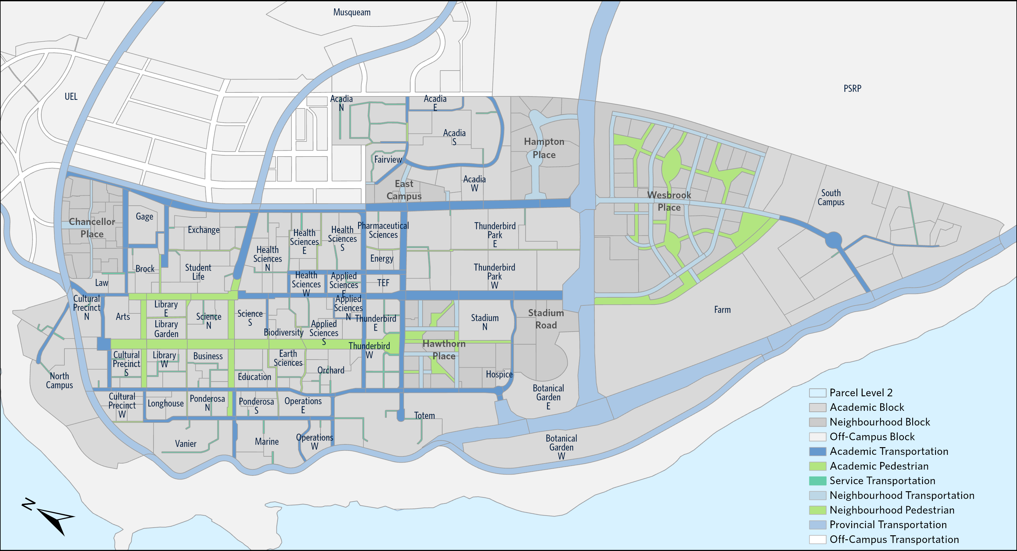
Second Level Parcels are divisions of First Level Parcels. They are bounded by roads, major pedestrian corridors, service lanes, or pedestrian paths.
The following are the general principles used for defining Second-level boundaries:
- Transportation corridors are subdivided by intersecting roads and pedestrian paths (on the south and west side of intersections).
- Second Level Block parcels are subdivisions of the Level 1 Blocks, using pedestrian paths or service lanes as dividers around building structures.
- For UNA blocks, boundaries follow Neighbourhood Plans and the legal parcels
- Where possible, parcels employ simple geometry (avoiding uneven boundary lines from specific physical features)
View a map of the Second Level Parcels. For a definition of property or parcel please refer to the Property Data Standard. For First Level Parcel please refer to the First Level Parcel Standard.
| Attribute | Definition |
|---|---|
| Name | Name assigned to the parcel (reference Parcel Naming Guidelines from First Level) |
| Type | The type of parcel based on its intended use (reference First Level Type) |
| Sub Type | A sub-categorization of parcels based on intended use (reference First Level Sub Type) |
| Jurisdiction | The extent or range of judicial, law-enforcement, or other authority (reference First Level Sub Type) |
| Ownership | The individual or entity who owns the land parcel |
| Easement | Does an Easement exist on the parcel? (Y/N) |
| Leased | Does a Lease exist on the parcel? (Y/N) |
| PID | A PID is a nine-digit number that uniquely identifies a parcel in the land title register of British Columbia |
| NP Site Name | Neighbourhood Plan name of site |
| Manage Organization | The organization that leases or manages the parcel |
| FSR | Floor Space Ratio, also known as Floor Area Ratio (FAR), is the numerical value derived when the building area is divided by the site area |
| Building Area | Total building area from Buildings within each parcel in m2 |
| Parcel Level 1 ID | The corresponding First Level property identifier |
| Parcel Level 1 Name | The corresponding First Level Name |
Compliance
This standard must be complied with every stage of the data lifecycle with the exception of any dispensations (see Dispensation section):
- All applications collecting parcel data must adhere to parcel boundaries as recommended in this standard.
- Enterprise Data Integration must adopt this standard.
Dispensation
Legacy systems are exempt from this data standard. Examples of legacy systems are:
- Student Information System (SIS)
As systems are replaced, adoption of this standard is required.
As existing systems change to adopt this standard, the Enterprise Data Governance team needs to be informed.
References
- UBC Properties Data Standard: https://datagovernance.share.ubc.ca/GSC%20Documents/2020/11172020%20Meeting/PropertyDataStandard_Draft20201106.docx?Web=1
- UBC Land First Level Parcel
